1. A relatively low-lying and flat land surface with least difference between its highest and lowest points is called a Plain.
2. Plains are broad, nearly level stretches of land that have no great changes in elevation.
3. They are generally lower than the land around them; they may be found along a coast or inland.
4. Coastal plains generally rise from sea level until they meet higher landforms such as mountains or plateaus.
5. Inland plains may be found at high altitudes.
Forms of Plain
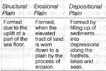
Structural Plain : Formed due to the uplift of a part of the sea floor. e.g. the Great Plain of USA. Erosion Plain Formed when the elevated tract of land is worn down to a plain by the process of erosion. e.g. Plain of North Canada.
Depositional Plain : Formed by filling up of sediments into depressions along the foothills, lakes and seas. e.g. Indo Ganga Plain.
DESERT
• A desert is a barren area of land where little precipitation occurs and consequently living conditions are hostile for plant and animal life. About to one-third of land surface of the Earth is arid or semi-arid.
• Deserts are formed by weathering processes as large variations in temperature between day and night put strains on the rocks which consequently break in pieces.
• The major hot deserts of world are located on the western coasts of the continents between latitudes 15° and 30°N and South (S) because the effects of off-shore trade wind. Some of the examples arc Sahara, Arabian, Great Australian Desert, etc.
• The cold deserts are located in the interior of the continents such as Gobi, Talda Makan etc and some are found at some distance from the sea, such as Atacama. This deserts are dry due to the effect of orographic barrier.
ISLANDS
An island is any piece of land that is surrounded by water. A grouping of geographically or geologically related islands is called an
archipelago. The various types of islands are named according to the way they were formed.
Types of Island
They are as follows :
Continental Island : t is simply an island that rests on the continental shelf. Because of this, these islands are always quite close to a given continent. Also, the water level around a continental island is very shallow, typically less than 600 feet. Canadian island of new found land is a continental island, as is Greenland. Great Britain is the largest continental island in Europe.
Volcanic Islands : They are formed when volcanoes deep in the ocean rise above the water's surface.
Coral Island : It is an island that forms a ring and partially or totally encloses a shallow body of water or lagoon. Coral islands, which are large collections of coral a top rock (usually volcanic) in the ocean. Lakshadweep island in Indian ocean is best example of coral islands.
Alluvial Islands : They are formed by the outward flow of water depositing silt and gravel at the mouth of a river. New Moore island at the mouth of Ganga river in West Bengal is an alluvial island.
Barrier Islands : They are formed by waves depositing sand on the shallow ocean bottom as they crash on the shoreline.
Tectonic Island : They are formed by the result of tectonic activity. By the tectonic movement long island arcs (archipelagoes) are formed. Indonesia, Philippines, Japan groups cf island arc best example of it.
LAKES
A lake is a body of water surrounded by land from all the sides. A lake ca.n be fed and drained by rivers and streams.
Types of Lakes
Lakes can be classified as Tarn Tarn lakes (also often classified as Alpine lakes) are usually associated with glacial regions areas that have
been glaciated in the past. These follows form as the ice scours out the side of a hill, creating what is called a cirque.
Tarn Lake : Tarn lakes from the last ice ages are evident along some slopes of the Adirondack Mountains and from more recent glaciation in the European Alps.
Rift Valley : Lake Rift valley lakes occur in areas where rock is pulling apart. As a narrow wedge of land drops from the movement, a long, narrow lake often forms. The Rift valley, which cuts through Africa and Asia, contains the largest group of such lakes, including lake
Nyasa.
Crater Lake : Crater lakes form at a volcanic peak. When an extinct volcano collapses, it often leaves a somewhat
circular depression; water from rain and runoff eventually fills the lake. Crater lake in Oregon is a good example of such a lake.
Deflation Lake : Deflation lakes usually occur in deserts as the wind blows out depressions in the sand. If the hole reaches the local groundwater table, it can create an oasis. Such features dot the Sahara desert in Africa which are locally called Oasis.
Oxbow Lake : Oxbow lakes are created by a curved river meander that was cut off by sediment or other means, creating a bowed shaped lake. The Mississippi River shows evidence of past Oxbow lakes.
Artificial Lake : Artificial lakes are those usually formed by the damming of a river. These lakes are usually created to regulate the flow of a seasonal flooding river and many times offer a constant supply of potable (drinkable; water or generated electricity).
1. A relatively low-lying and flat land surface with least difference between its highest and lowest points is called a Plain.
2. Plains are broad, nearly level stretches of land that have no great changes in elevation.
3. They are generally lower than the land around them; they may be found along a coast or inland.
4. Coastal plains generally rise from sea level until they meet higher landforms such as mountains or plateaus.
5. Inland plains may be found at high altitudes.
Forms of Plain
Structural Plain : Formed due to the uplift of a part of the sea floor. e.g. the Great Plain of USA. Erosion Plain Formed when the elevated tract of land is worn down to a plain by the process of erosion. e.g. Plain of North Canada.
Depositional Plain : Formed by filling up of sediments into depressions along the foothills, lakes and seas. e.g. Indo Ganga Plain.
DESERT
• A desert is a barren area of land where little precipitation occurs and consequently living conditions are hostile for plant and animal life. About to one-third of land surface of the Earth is arid or semi-arid.
• Deserts are formed by weathering processes as large variations in temperature between day and night put strains on the rocks which consequently break in pieces.
• The major hot deserts of world are located on the western coasts of the continents between latitudes 15° and 30°N and South (S) because the effects of off-shore trade wind. Some of the examples arc Sahara, Arabian, Great Australian Desert, etc.
• The cold deserts are located in the interior of the continents such as Gobi, Talda Makan etc and some are found at some distance from the sea, such as Atacama. This deserts are dry due to the effect of orographic barrier.
ISLANDS
An island is any piece of land that is surrounded by water. A grouping of geographically or geologically related islands is called an
archipelago. The various types of islands are named according to the way they were formed.
Types of Island
They are as follows :
Continental Island : t is simply an island that rests on the continental shelf. Because of this, these islands are always quite close to a given continent. Also, the water level around a continental island is very shallow, typically less than 600 feet. Canadian island of new found land is a continental island, as is Greenland. Great Britain is the largest continental island in Europe.
Volcanic Islands : They are formed when volcanoes deep in the ocean rise above the water's surface.
Coral Island : It is an island that forms a ring and partially or totally encloses a shallow body of water or lagoon. Coral islands, which are large collections of coral a top rock (usually volcanic) in the ocean. Lakshadweep island in Indian ocean is best example of coral islands.
Alluvial Islands : They are formed by the outward flow of water depositing silt and gravel at the mouth of a river. New Moore island at the mouth of Ganga river in West Bengal is an alluvial island.
Barrier Islands : They are formed by waves depositing sand on the shallow ocean bottom as they crash on the shoreline.
Tectonic Island : They are formed by the result of tectonic activity. By the tectonic movement long island arcs (archipelagoes) are formed. Indonesia, Philippines, Japan groups cf island arc best example of it.
LAKES
A lake is a body of water surrounded by land from all the sides. A lake ca.n be fed and drained by rivers and streams.
Types of Lakes
Lakes can be classified as Tarn Tarn lakes (also often classified as Alpine lakes) are usually associated with glacial regions areas that have
been glaciated in the past. These follows form as the ice scours out the side of a hill, creating what is called a cirque.
Tarn Lake : Tarn lakes from the last ice ages are evident along some slopes of the Adirondack Mountains and from more recent glaciation in the European Alps.
Rift Valley : Lake Rift valley lakes occur in areas where rock is pulling apart. As a narrow wedge of land drops from the movement, a long, narrow lake often forms. The Rift valley, which cuts through Africa and Asia, contains the largest group of such lakes, including lake
Nyasa.
Crater Lake : Crater lakes form at a volcanic peak. When an extinct volcano collapses, it often leaves a somewhat
circular depression; water from rain and runoff eventually fills the lake. Crater lake in Oregon is a good example of such a lake.
Deflation Lake : Deflation lakes usually occur in deserts as the wind blows out depressions in the sand. If the hole reaches the local groundwater table, it can create an oasis. Such features dot the Sahara desert in Africa which are locally called Oasis.
Oxbow Lake : Oxbow lakes are created by a curved river meander that was cut off by sediment or other means, creating a bowed shaped lake. The Mississippi River shows evidence of past Oxbow lakes.
Artificial Lake : Artificial lakes are those usually formed by the damming of a river. These lakes are usually created to regulate the flow of a seasonal flooding river and many times offer a constant supply of potable (drinkable; water or generated electricity).